Hey look, topography.
Next to the climate, the thing I miss the most about living on the Left Coast, is the visual relief. It's hard to go anywhere west of the Cascades and not know that mountains are everywhere out here. In some cases they virtually plunge straight into the sea. Since moving back to Florida, every once in a while I get a tiny spark of excitement when I see a cloud formation that for the briefest of moments looks like mountains, wishful thinking I know.

On our project flights we quite often started pretty close to the coastline which allowed for some beautiful views during the commute. One of the best things about this job is view out the office window.
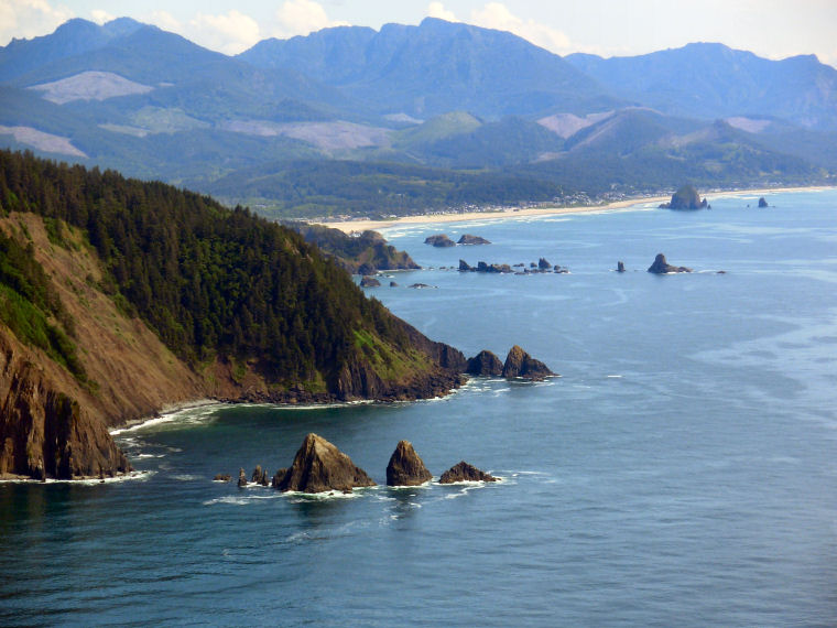
The shot below is of an archway rock that I found interesting, but also I believe that the green area near the parking lot is the site in Ecola State Park where Spielberg and company built the restaurant prop where Mikey aligned the amulet to find the entrance of the caves to begin their adventure.


The rock pictured above is Haystack Rock off Canon Beach. It was one of the features also used by Mikey to align the medallion.

This is Tillamook Rock Lighthouse. What can I say I just love lighthouses, especially ones on islands.
Below are a few pictures of Port Angeles, WA. I worked there from Dec 2002 through July 2004 when I left to go to flight training. I lived just east of there in a town called Sequim(pronounced with the "e" silent like Skwim), *Ironically enough due to the clouds that day, I was unable to take an aerial shot.
*Side note: Sequim is also known as Sunny Sequim, or the banana belt, as the rainfall averages around 16" a year due to the rain shadow effect of the Olympic Mountains. Pilots also call it the "Blue Hole" because when the entire area is overcast as far as the eye can see you can often find a nice, big, predictable hole to get through and stay flying under Visual Flight Rules, VFR.
I did get a few shots of Port Angeles though.
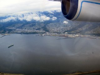
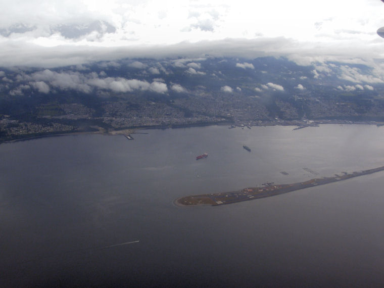
Here's a pretty good shot of the waterfront. My office was at the foot of that group of piers in the middle.

This is another shot of the harbor that shows Ediz Hook, the spit that made Port Angeles a natural deepwater safe harbor that is still used by the large vessels headed into and out of Seattle while waiting for pier space. There's a Coast Guard Air Station at the tip of the Hook. Port Angeles also has ferry service to Victoria, BC. If you're ever in the area, it's well worth the trip. Victoria feels more British than London.

This is a shot of the east side of town near Morse Creek. You can make out US 101 as it snakes its way down and around the gulley. That's a Wal-mart there on the left, also doubles as a parking lot for RV's during the summer, or at least that seems like its intended use.
Not sure what my next post will entail, but I have plenty more pictures. When I get back home, I will post some "historical" photos from some of my earlier escapades. But I should have enough in my camera and on my laptop to keep going for a little while longer.
On our project flights we quite often started pretty close to the coastline which allowed for some beautiful views during the commute. One of the best things about this job is view out the office window.
The shot below is of an archway rock that I found interesting, but also I believe that the green area near the parking lot is the site in Ecola State Park where Spielberg and company built the restaurant prop where Mikey aligned the amulet to find the entrance of the caves to begin their adventure.


The rock pictured above is Haystack Rock off Canon Beach. It was one of the features also used by Mikey to align the medallion.

This is Tillamook Rock Lighthouse. What can I say I just love lighthouses, especially ones on islands.
Below are a few pictures of Port Angeles, WA. I worked there from Dec 2002 through July 2004 when I left to go to flight training. I lived just east of there in a town called Sequim(pronounced with the "e" silent like Skwim), *Ironically enough due to the clouds that day, I was unable to take an aerial shot.
*Side note: Sequim is also known as Sunny Sequim, or the banana belt, as the rainfall averages around 16" a year due to the rain shadow effect of the Olympic Mountains. Pilots also call it the "Blue Hole" because when the entire area is overcast as far as the eye can see you can often find a nice, big, predictable hole to get through and stay flying under Visual Flight Rules, VFR.
I did get a few shots of Port Angeles though.

Here's a pretty good shot of the waterfront. My office was at the foot of that group of piers in the middle.
This is another shot of the harbor that shows Ediz Hook, the spit that made Port Angeles a natural deepwater safe harbor that is still used by the large vessels headed into and out of Seattle while waiting for pier space. There's a Coast Guard Air Station at the tip of the Hook. Port Angeles also has ferry service to Victoria, BC. If you're ever in the area, it's well worth the trip. Victoria feels more British than London.

This is a shot of the east side of town near Morse Creek. You can make out US 101 as it snakes its way down and around the gulley. That's a Wal-mart there on the left, also doubles as a parking lot for RV's during the summer, or at least that seems like its intended use.
Not sure what my next post will entail, but I have plenty more pictures. When I get back home, I will post some "historical" photos from some of my earlier escapades. But I should have enough in my camera and on my laptop to keep going for a little while longer.
posted by IFly at 6/21/2006 10:40:00 PM
![]()
![]()


0 Comments:
Post a Comment
<< Home